A professional Topographic survey also known as Topographical Survey is the crucial first step for every successful construction, design, or development project. Without an accurate map of your site’s features, levels, and contours, you are essentially working blind from the start, exposing your project to unforeseen risks, delays, and costly errors.
This detailed land survey provides the essential foundation for all following work. For any project across Lincolnshire and the surrounding counties, understanding why this survey is not just a formality but a vital investment is key. Here are the five main reasons:
Ensure Accurate Design & Planning
Every great design starts with a great site. But what if your site is misleading?
Architects and designers need a reliable and accurate site plan to begin their work. A topographic survey provides exactly that: a detailed digital plan showing the precise location of all features alongside exact ground levels. This detailed information allows them to design a plan that works in-line with the site, maximising the potential of the available space while preventing the costly surprises that arise when a design based on assumptions meets the reality of the land.
Support Your Planning Application
Is there anything more frustrating than having a planning application delayed or denied due to a lack of information?
Should your project require planning permission, your local authority will mandate a detailed site plan showing the property’s current state to a recognised standard. A professional topographic survey delivers the comprehensive and detailed existing site plan that councils require to validate an application, reducing the risk of costly delays.
Identify Potential Problems Early
It’s often what lies beneath the surface that can derail a project budget. What if you could see it all first?
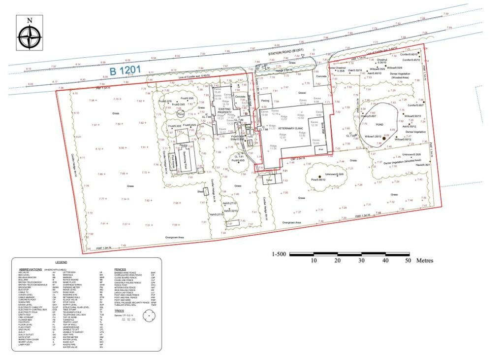
A thorough topographic survey acts as an x-ray of your site, revealing a comprehensive list of features that could become significant development constraints.
A detailed topographic plan will accurately map and identify:
- Existing buildings and any other permanent structures.
- Boundary lines, fences, and walls to check against property deeds.
- Site levels, contours, and gradients across the entire area.
- Drainage features like manholes, inspection covers, and gullies.
- The position, canopy spread, and trunk diameter of individual trees.
- Ground surfaces, such as grass, tarmac, and gravel pathways.
- Visible utilities infrastructure and street furniture.
Identifying these features early saves invaluable time, protects your budget, and prevents future boundary disputes.
Save Significant Time and Money
Are you viewing the survey as a project cost, or as an insurance policy against much larger expenses?
While a survey is an upfront cost, it pays for itself many times over by preventing errors. According to guidance from industry bodies, accurate land and topographic surveys are fundamental to managing project risk. The cost of not having one can be immense, leading to redesign fees, construction delays, and unexpected groundwork charges. A topographic land survey is an investment in certainty.
Create a Detailed Digital Record
How do you ensure your architect, engineer, and landscape designer are all working from the same page?
In modern construction, the deliverable from a survey is as important as the fieldwork itself, it provides your site data in versatile digital formats, as a 2D or 3D CAD drawing (DWG file) or PDF. This digital model becomes the documentation for all project stakeholders, ensuring everyone is working from the same accurate information, improving collaboration from start to finish.
Start Your Project on Solid Ground with a Topographic Survey
Whether planning for a single plot of land or a large scale development, a topographical survey is the bedrock of a successful project. It eliminates guesswork, reduces risk, and provides the clarity needed to move forward with confidence.
Newman Surveying specialises in producing highly accurate and detailed topographic surveys across Lincolnshire using the latest industry technology, we provide the certainty that architects, developers and landowners need to proceed with their plans successfully.
To learn more about what our Topographical Survey service includes, or to get a free, no obligation quote for your project, contact our team today.